At the Breney Glacier in Switzerland.
Searching for adventure and to spend time in the mountains, our member Deniz has gone from studying volcanoes in the Andes previously, to glaciers in the Alps for his current PhD research.
For this Meet our Members interview Deniz told us what exactly he is researching in glaciers and how; why is this relevant and how new technologies are changing the work in his field of geosciences.
Deniz, can you explain us your current research?
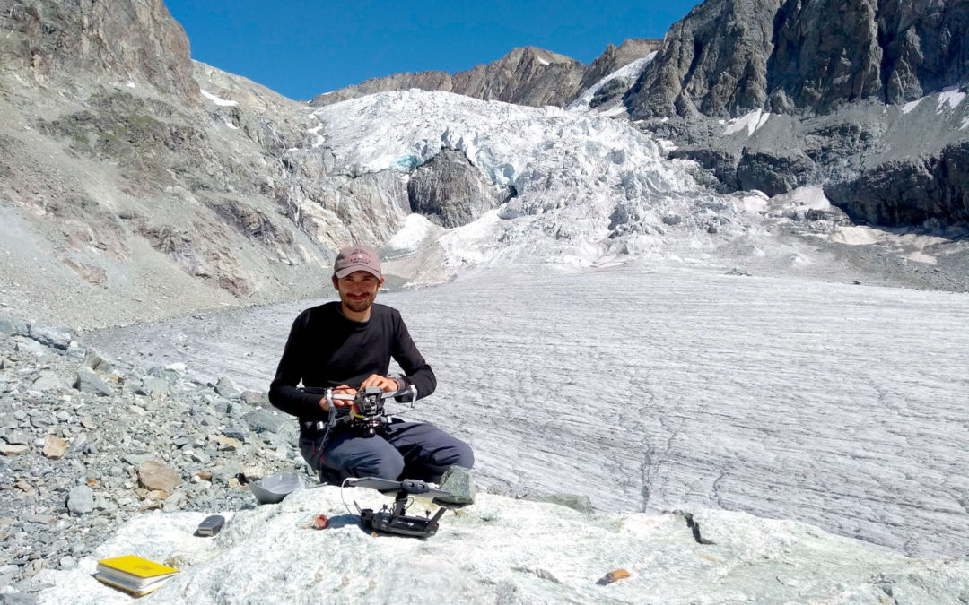
I’m studying debris-covered glaciers from high mountain regions, using remote sensing approaches, combining unpiloted aerial vehicles (UAV – aka drones) and satellite images to research how this debris cover changes in time and over the glaciers.
Some of these glaciers are situated in steep mountains where they are totally or partly covered by a layer of debris, which in this case is loose rock material. Imagine there is a high mountain rock cliff and suddenly a rock avalanche occurs – this loose material is deposited on the glacier ice surface, and then over time, it gets covered by a layer of this debris, affecting how the glacier melts and its response to climate change in comparison to debris-free glaciers.
The debris is variable in thickness: some parts show thicknesses of a meter or more of loose rock material piling up for example, while in others the cover is as thin as a couple of centimetres. When the debris cover is thin, the glacier ice underneath the debris is melting faster and when the debris cover is thick, the ice becomes thermally isolated, reducing the melt. I am working on an automated workflow to estimate the glacier-wide debris thicknesses from surface temperature measurements of satellites (thick debris is warmer than thin debris). These measurements and methods do have quite some uncertainties and high-resolution drones can help to understand them better.
Why is it important that it’s being researched?
In order to predict the melt of glaciers in time and due to climate change at high mountain regions, the information about the thickness of the debris cover is crucial for the calculation. Currently, scientists who are already modelling the melt of glaciers are not including this information because it doesn’t exist yet. Most glaciers are located in remote areas with difficult access so that in-situ measurements are not so doable, therefore a remote sensing approach is needed but current methods are not very good.
Why these predictions are important depends on the area, but we observe that wherever glaciers are located (with few exceptions), they all decline under climate change.
If we take the case of the Himalayan mountain range, many people there depend on water resources coming from river basins fed by glaciers or by melting snow, and this availability is influenced directly by the melt allowed by the debris cover. So whenever ice retreats and there is less water available it affects their agriculture and therefore their food supply, making it important to make predictions and understand the behaviour of glaciers and snow cover.
In the European Alps, we have more rock avalanches and rockfalls than we had 50 years ago, and this is a threat to the infrastructure, for the people living or working there, at the huts, the ski centres and more. So clearly there’s interest in how these landscapes behave in future.
")
Overlapping drone images allow building a 3D model of the surface (photogrammetry), a so-called digital elevation model.

This can also be done with thermal images showing a 3D thermal model of a debris-covered glacier surface with high temperatures (very thick debris) in red, intermediate temperatures (thin debris) in green and yellow and cold temperatures (very thin or no debris) in blue.
Which novel discoveries have you and your team made so far?
Temperature measurements from UAVs are more complicated than I initially thought and the interpretation must be done carefully. Also, the methods and models I’m using come with strengths and weaknesses, and the available data is not always (or never) perfect. This is sometimes frustrating but I also think that we gain new insights by testing the limits of our methods.
There is a great potential for studying the earth surface in new technologies like drones equipped with very small thermal sensors or cloud computing systems that allow us to analyse long time series of satellite data. For other research fields, this might not always be cutting edge new stuff, but in the geosciences, it’s still kind of new. Also important, the available satellite data is constantly increasing. For example, the Landsat satellite measures every 16 days the same spot on the earth for the last 36 years or so. Observations of the earth surface for several decades allow us to look at ‘slow’ large-scale processes such as the shrinkage of glaciers, changes in river pathways or coastal erosion.
How would you say climate change has affected glaciers in recent years?
Since I’m not a climatologist I’m citing the IPCC (International Panel on Climate Change), which says if nothing changes in our emission of greenhouse gases, global mountain glaciers are projected to reduce the ice mass by 37 to 57% by the end of 2100, whereas for regions with small glaciers as the European Alps, for example, this goes up to 80%. And as I said before this has an impact on available water resources, ecosystems and sea level, plus contributing to a feedback loop called the ice-albedo effect which leads to further warming.
What I can say is that as global mean temperatures rise, high mountainous regions experience a decline of snow and ice cover as well as permafrost degradation, resulting in decreased stability of mountain slopes (more rockfalls). Climate, glaciers and landscapes are interacting constantly.
What do you like about your job?
Probably fieldwork (laughs). This is how it started kind of because you are able to go to the mountains and do stuff there. That’s just exciting and can be adventurous and I enjoy it very much. But also, by studying volcanoes and now having moved to cold temperatures and glaciers, I think I’m interested in extreme landscapes in general because they show how certain processes on the earth’s surface work when they are very dominant. For example the way glaciers erode into the mountains and leave steep headwalls behind, or how volcanic deposits are able to change coastlines or river pathways.
If you spend a long enough time in the mountains and you look at these landscapes, the more you understand how landscapes evolve over time and what happened in the past, you kind of start reading them.


At the Oberaletsch Glacier located in the Bernese Alps, Switzerland. With a 9 km length, this area was declared a UNESCO World Heritage Site in 2001.
Was there something else you wanted to do professionally?
I think studying nature somehow was what I wanted for quite a long time, so it could have been biology and then studying monkeys or trees, who knows. But for a while now I’ve been interested in geosciences in general. Even though I’m currently researching glaciers, I consider myself a geoscientist in general and not only specialized in glaciers.
Where else can you be found when not working?
Probably at the bouldering gym.
Why did you join Engelnest and how has it improved your work-life quality?
Before the pandemic hit I used to work physically in Potsdam at the German Research Center of Geosciences, and I had to commute like one hour and a half from door to door just to work. With the lockdown, I didn’t want to work from my living room all day, and a coworking space was the best solution. I’m happy about not having to commute anymore.
On the other hand, I miss the connection with other scientists and those between doors or coffee break chats. I think they really contribute to your research and how you progress. I’m lacking that exchange and is definitely not the same with only Zoom meetings, as the conversation there doesn’t flow that easily as in the hallway.
What do you like about Engelnest?
Engelnest has kind of a living room atmosphere that I enjoy, so sometimes I’m working until very late and it’s cool that this is possible here.
Even though I mostly come here for focused work and then leave, I have enjoyed participating in the community gatherings and meeting the people around here. Also through Engelnest, I got to know people from my direct neighbourhood, as for example Jan who lives on the same street as I do.
We hope you enjoy getting to know our members. If you would like to network, collaborate with one of them or join our community, contact us here
Subscribe
and get our news, events and offers!
(We promise not to spam you. Just an occasional email every 2 months.)